Geology and Geophysics Collaboration in Oil and Gas Industry Exploration

BANDUNG, itb.ac.id – The webinar series by Geological Engineering Institut Teknologi Bandung, Geologi ITB Greets, held its 17th episode on Saturday (6/3/2021). This webinar episode was titled "The Use of Geology and Geophysics Exploration Method in Oil and Gas/Geothermal Industry". This webinar presented Dr.Eng. Ir. Prihadi Sumintadireja, M.S., a lecturer from Applied Geology Research Group.
Geology ITB Greets also organize a disaster relief fundraising that is directed at the victim of land-disaster. The webinar was held virtually through Zoom meeting and was broadcasted via Teknik Geology ITB YouTube channel.
At the beginning of the webinar, Agus Mochammad Ramdhan, Ph.D. delivered his opening remarks. He explained the connection between geology and geophysics in the exploration method. According to him, the geophysics exploration method is very effective to cover a large area and can penetrate deeper geological layers compared to current drilling technology. This method is closely related to geology because it is capable to provide geological interpretation information for great depth and large areas.
In the presentation session, Dr. Prihadi Soemintadireja explained the stages in the exploration study. According to him, there are three main stages in the exploration study. The stages are data collection, data processing, and data procession.
Exploration Stages
In conducting data collection, the work plan needs to be prepared in accordance with the Geological and Geophysical exploratory research framework that has been agreed upon by the company management. The data collection process needs to be done with specific protocol and technology, both hardware and software, in accordance with the former exploratory research framework. The study results will be presented and written in the form of a report.
Dr. Prihadi then explained that, based on his experiences, he often encounters study data with a different result. According to him, this is highly dependent on the processing and interpellation of the research data. Therefore, a deep understanding of the geological concepts is necessary to produce an accurate result.
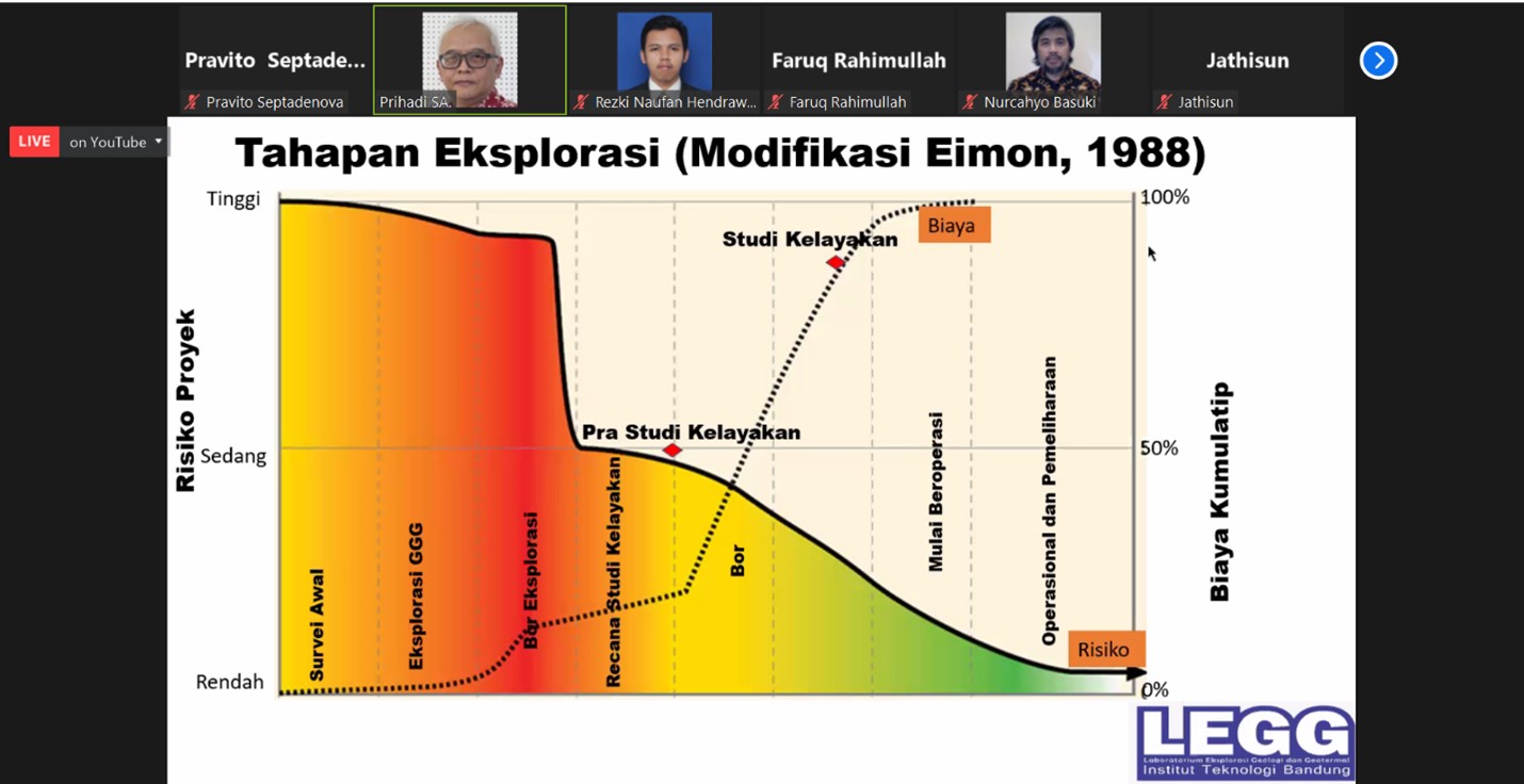
The graphic above shows the stages of exploration in terms of cumulative risks and potential costs. Dr. Prihadi explained that the most crucial initial survey methods are surface geology study and remote sensing. Those methods have a very high risk of error. If there is a mistake in this phase, the whole stage needs to be started all over.
The next stage, the pre-feasibility study, has a lower risk than the previous stage. But it is still considered as high because the analysis was carried out based on assumption data. In the feasibility study, the project risk graph has been sloping because it already uses collected data. The cumulative cost of this phase increase dramatically because these chains of processes until the post-operation phase are very costly.
Geological and Geophysical Methods that are used on Exploration
Dr. Prihadi continued his presentation with an explanation of geological and geophysical methods that are commonly used in exploration. The commonly used geological method are stratigraphic, sedimentology, and geology structure. The most advanced geophysics methods that are used in the oil and gas industry are seismic reflection and geothermal magnetotelluric.
The Magnetotelluric (MT) method is often chosen because of its depth penetration capability. Dr. Prihadi explained that Control Souce Audio Magnetotelluric can reach up to 3-4 kilometers below the sea surface. By using natural electromagnetic sources, which are thunder and sunlight, MT can be installed for 24 hours non-stop nature-emitted signal monitoring and measuring.
Manufactured-magnetotelluric or CSAMT can even reach greater depth by using dynamite that is detonated by electrical current. The penetration depth can reach up to 1200m below the bottom of the sea. The data that is collected through seismic reflection and CSAMT can be reprocessed by using the geology structure method to produce clearer images and reflections. The weakness of this method is that it would produce poor-quality data if used on volcanic or carbonate rock layers. The explosion energy from dynamite will be absorbed thus minimizing the seismic data that can be detected.
"The data will never be sufficient enough, but we can optimize this data and limiting the problems," said Dr. Prihadi as a closing remark.
Reporter: Ferio Brahmana (Geological Engineering, 2019)
Translator: Favian Aldilla R (Civil Engineering, 2019)

scan for download