December 2018 Anak Krakatoa Volcano: Providing the Necessary Benchmark for Accurately Testing Tsunami Modeling Solutions
By Adi Permana
Editor Adi Permana

The movement of tectonic plates not only causes earthquakes but also generates subduction zones, producing volcanoes. The confluence of several world tectonic plates creates a volcanically active terrestrial chain known as the Pacific Ring of Fire.
Being located on the so-called Pacific Ring of Fire, Indonesia must be prepared for the risks of natural disasters such as volcanic eruptions, earthquakes, and tsunamis. Indonesia has 127 volcanoes and is the country with the most active volcanoes in the world.
The Indonesian Centre of Volcanology and Geological Hazard Mitigation states that 12 volcanoes in Indonesia potentially generate tsunamis. The volcanoes are Anak Krakatau, Rinjani, Tambora, Rokatenda, Ile Werung-Hobal, Teon, Kie Besi, Gamalama, Gamkonora, Awu, Banua Wuhu, and Ruang.
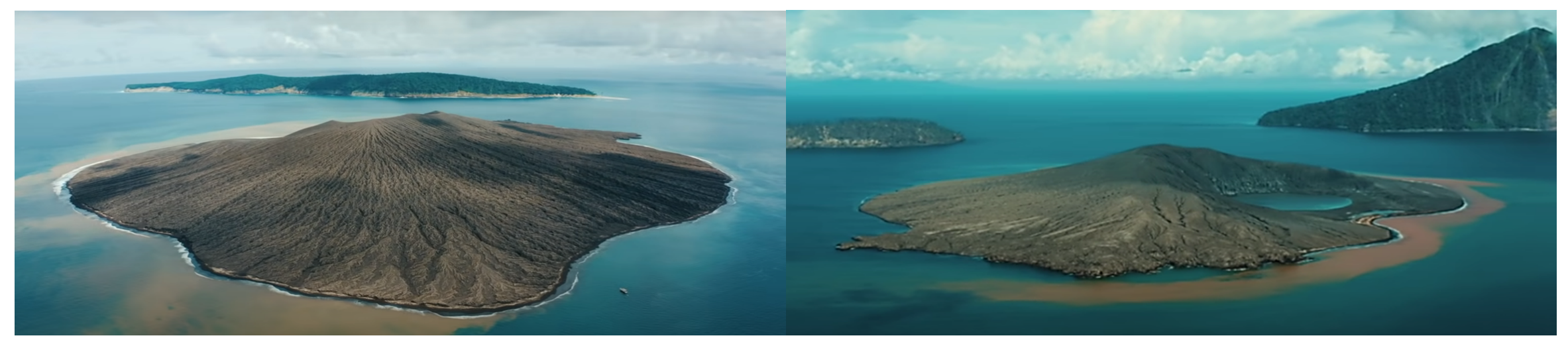
A figure of Mount Anak Krakatau in 2016 (Indonesia Nature Film Society, source: https://youtu.be/IPdzXh5ZmQo)
Volcanogenic Tsunamis
Mirzam Abdurrahman, a scientist from the Department of Geological Engineering Institut Teknologi Bandung, says, "mountains located in the middle of the sea, such as Mount Anak Krakatau, have great potential to generate volcanogenic tsunamis. Volcanogenic tsunamis occur because of sudden changes in sea volume due to volcanic eruptions."
Abdurrahman reveals four possible causes of volcanogenic tsunamis. First, the collapse of the water column due to volcanic eruptions. Second, the formation of a caldera due to a large volcanic eruption. Third, the landslide of volcanic material. Fourth, pyroclastic flows that descend along the mountainside at high speed during a volcanic eruption can push up sea levels if the volcano is on or near the coast.
The first and second causes generate high-wave tsunamis, which are generally preceded by a receding in sea level. Whereas tsunamis caused by landslides and pyroclastic flows generally produce smaller wave heights but can be very dangerous because a receding sea level does not precede them.
The 2018 Mount Anak Krakatau volcanogenic tsunami on the Sunda strait
The December 22, 2018, volcanogenic tsunami on the Sunda strait was a complete shock. How come? The tsunami occurred without being preceded by an earthquake or a receding sea level.
Indonesia's current volcano monitoring method only records the seismic activity and other signals caused by magma rising through the volcano. Therefore, the 2018 non-seismic tsunami on the Sunda strait would not be detected using currently available methods. The lack of a tsunami warning just minutes after the first wave resulted in heavy casualties and damage in the affected areas.
What actually caused this tsunami?
This volcanogenic tsunami was caused by the west flank collapse of Mount Anak Krakatau, which reduced the island's height by more than 50%. The collapse of Anak Krakatau in 2018 resulted from long-term destabilization processes.
"The location and extent of the 2018 failure were also potentially controlled by the underlying structure of the caldera margin, internal structural discontinuities, and the location of previous instabilities. Past marine soundings also show that the volcano was built atop and outwards from the steep 1883 caldera wall, likely creating gravitational instability."
This kind of volcanic disaster is very difficult to predict. "If a large-scale landslide occurs in a volcanic area due to long-term instability and can occur without a typical change in magmatic activity at the volcano, this means that the phenomenon can occur suddenly and without any apparent warning," he adds.
The tsunami caused by the flank collapse reached a wave height of 80 m around Mount Anak Krakatau, while on the coast of Banten and Lampung, the wave height reached 13 m. The tsunami caused 437 fatalities, 14,059 injuries, and displaced 33,719 people.
Not only that, the collapse of Mount Anak Krakatau also caused an eruption due to the landslide releasing pressure on the magma system. Post-collapse eruptions produced volcanic material that buried the scar and landslide deposit.
Abdurrahman collaborated with scientists from various institutions to study the flank collapse of Anak Krakatau. This study has been published in Nature Communications with the paper entitled "Submarine landslide megablocks show half of Anak Krakatau island failed on December 22, 2018."
The lead author of the study, James E. Hunt, says, "detailed flank collapse reconstructions are key to understanding their mechanisms, timing and associated tsunami generation, which are essential to better identify the factors controlling failure and improving global monitoring of volcano instability hazards."
The research involving 11 institutions studied not only the subaerial components characterization of the collapse but also its submarine components. "Submarine datasets hold the key to a more accurate understanding of the Anak Krakatau failure since observations of the landslide deposit provide an independent means of measuring the failure volume and investigating landslide emplacement mechanisms," says Hunt, a senior researcher of marine geoscience from National Oceanographic Centre, UK.
The collapse occurred after several months of a relatively intense phase of eruptive activity. "Our observations suggest that this activity preconditioned failure by loading the west flank with lavas and ejecta," Hunt says. Thus the incipient failure plane had at least partially formed during the months prior to collapse.
The observation results show that the deposits are dominated by large, angular blocks with a total deposit volume of ~0.214 km3. These blocks moved 1.5 km from Anak Krakatau and rose to more than 70 meters above the seabed. However, the landslide deposit is now buried under post-collapse eruption material. Therefore, landslide surveys are carried out as soon as possible before being buried by the next eruption material or affected by dynamic sea changes.
Although the 2018 flank collapse reduced the area of Anak Krakatau from 3.19 km2 to 1.7 km2, observation shows that volcaniclastic deposits from the post-collapse eruptions led to the island exceeding its pre-collapse area within weeks, reaching 3.27 km2.
Hunt says, "the landslide triggered a period of intense volcanism that generated a greater volume of material than was lost during the flank collapse, but 90% of those materials were deposited offshore."
"Furthermore," he adds, "the active modification of the seafloor during this time highlights that major volcanic environments can remain highly dynamic months after a flank collapse and illustrates the potential for collapse to initiate vigorous eruptive activity, which then rapidly obscures evidence of the collapse itself."
The 2018 Anak Krakatau flank collapse and tsunami is the only major island-arc collapse event recorded by modern instrumentation, satellite technology, high-resolution seabed mapping, and detailed observations of tsunami impact. "The Anak Krakatau event, therefore, is a unique opportunity to fully parameterize a flank collapse, providing the necessary benchmark for accurately testing tsunami modeling solutions."
.jpg)
.jpg)
.png)
.jpg)
.jpg)
